AROSICS
Keywords: Earth & environment, Remote sensing, Time series analysis, Python, Phase correlation, Image co-registration, Geometric pre-processing, Sub-pixel, Optical, Radar, Fourier shift theorem
AROSICS is an automated and robust open-source image co-registration software for multi-sensor satellite data. The Python package performs automatic subpixel co-registration of two satellite image datasets based on an image matching approach working in the frequency domain, combined with a multistage workflow for effective detection of false-positives.
AROSICS was developed at the German Research Centre for Geosciences Potsdam (GFZ) in the context of GeoMultiSens. The underlying algorithm has been published in Scheffler et al. 2017:
- Scheffler, D., Hollstein, A., Diedrich, H., Segl, K., Hostert, P. (2017): AROSICS: An Automated and Robust Open-Source Image Co-Registration Software for Multi-Sensor Satellite Data. - Remote Sensing, 9, 7, 676. https://doi.org/10.3390/rs9070676
User group and accessibility
The package is freely available from the Python package index or conda-forge and is already widely used by a community of geospatial analysts and remote sensing experts.
The source code can be accessed at the GitLab repository or its mirror repository on GitHub. Documentation is available here.
Features
AROSICS detects and corrects local as well as global misregistrations between two input images in the subpixel scale, that are often present in satellite imagery. The algorithm is robust against the typical difficulties of multi-sensoral/multi-temporal images. Clouds are automatically handled by the implemented outlier detection algorithms. The user may provide masks to exclude certain image areas from tie point creation. The image overlap area is automatically detected. AROSICS supports a wide range of input data formats and can be used from the command line (without any Python experience) or as a normal Python package.
Two co-registration modes are available: the local co-registration approach accounts for locally varying shifts and computes hundreds of tie points spread over the entire image overlap whereas the global co-registration approach only corrects a static, translational X/Y shift.
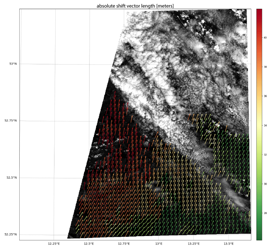
AROSICS provides a lot of functionality to visualize the initial mis-registration and to create interactive plots in a Jupyter notebook. The figure shown here, e.g., visualizes the computed shift vectors (local co-registration approach) after filtering false-positives, mainly due to clouds in the target image.
Acknowledgements
The development of AROSICS was funded by the German Federal Ministry of Education and Research (project grant code: 01 IS 14 010 A-C).
Publications
AROSICS: An Automated and Robust Open-Source Image Co-Registration Software for Multi-Sensor Satellite Data
Scheffler D - Zenodo - 2025
Contribution of ECOSTRESS thermal imagery to wetland mapping: Application to heathland ecosystems
Loizeau-Woollgar L, Rapinel S, Pellen J, Clément B, Hubert-Moy L - ISPRS Journal of Photogrammetry and Remote Sensing - 2025
AROSICS: An Automated and Robust Open-Source Image Co-Registration Software for Multi-Sensor Satellite Data
Scheffler D, Hollstein A, Diedrich H, Segl K, Hostert P - Remote Sensing - 2017