Simplifying Earth Observation Data Access with Terragon
In recent years, advances in Earth observation technologies have transformed our ability to monitor and understand the planet. Satellites continuously capture vast amounts of data, including imagery, vegetation indices, temperature measurements and wind speeds. This data supports critical fields such as climate research, disaster response, agriculture and urban planning. However, accessing and preparing this data remains a significant challenge.
Researchers and developers often encounter fragmented datasets, inconsistent formats and specialised APIs tied to specific satellite platforms. As AI and computer vision systems are becoming increasingly dependent on large-scale, multi-temporal and multi-modal data, the creation of integrated, analysis-ready data cubes is both essential and technically demanding.
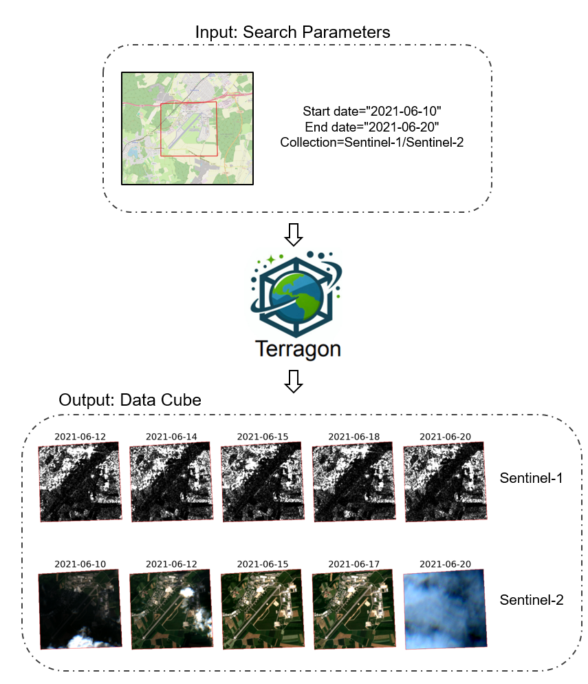
Terragon ('Earth (Poly)gon') is a Python package designed to simplify access to remote sensing data. Unlike traditional tools that are limited to specific satellites or platforms, Terragon provides a unified, intuitive interface for working with diverse sources. Users can define their area of interest, time range, satellite collections and additional search parameters, such as cloud cover thresholds or specific product types. Terragon then handles the entire process, from data discovery and retrieval to alignment and conversion into standardized spatio-temporal data cubes.
Terragon currently supports major platforms including Google Earth Engine, Microsoft Planetary Computer, the Copernicus Data Space Ecosystem and the Alaska Satellite Facility. By harmonising coordinate systems, spatial resolutions and formats, Terragon drastically reduces pre-processing time and ensures consistency for spatial analysis and machine learning workflows.
Terragon’s integrated data cubes support a wide range of applications, including rapid detection of floods and wildfires, monitoring drought conditions and crop health, analyzing long-term climate trends, and tracking urban sprawl and land use change.Users can detect and map wildfires and floods, improve weather predictions by combining satellite and atmospheric data, and enhance crop yield estimates through integrated monitoring.
Here at the Technical University of Munich (TUM) and the German Aerospace Center (DLR), we actively use Terragon for research projects focusing on the detection of natural hazards, environmental monitoring and the spatio-temporal analysis of changes to the Earth's surface.
Terragon has been designed with accessibility in mind, to meet the needs of users with limited technical or financial resources. Whether you are an academic researcher, an environmental analyst, a disaster response professional or an urban planner, Terragon simplifies data access, allowing you to concentrate on gaining insights rather than dealing with technical complexities.
Developed as part of a Helmholtz Imaging project "WeMonitor", Terragon continuously evolves based on community feedback, integrating additional data providers and advanced processing techniques such as mosaicking and resampling. Join our growing community and help shape Terragon into an even more powerful and versatile tool (github.com/drnhhl/terragon).
With Terragon, accessing Earth observation data becomes easier and more affordable, making it possible to drive innovation and create real environmental impact.